
Page 37 - The Petroleum System From Source to Trap
P. 37
2. Petroleum System Logic as an Exploration Tool 29
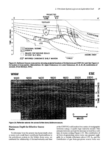
PROJECTED
SCHLEE COST
A DOME B-2 A'
0 � -- -- -- -- -- -- -- -- -- -=� � == == � ==== == � -- -- -- -- -- -------------
- - -
7 ....... ....... . - . - · - · - · -
= :: :: I REGIONAL SEISMIC ....... _ . - . - .
8 :..:=1 EVENTS - - - - - - - -
D MAJOR CRETACEOUS SEALS
9 IN COST B-2 WELL OCEANIC CRUST
� INFERRED CARBONATE SHELF MARGIN 10 MILES
Figure 2.5. Baltimore Canyon cross section showing projected locations of Schlee dome and COST-B-2 well. See Figure 2.4
for location of cross section. Abbreviations: UK, Upper Cretaceous; LK, lower Cretaceous; JO, Jl, Jll, Jill, subdivisions of
Jurassic. (From Mcintyre, 1976.)
WNW ESE
0
CJ)
1 �
0
0
2 �
z
-
4
0 4
MILES
Figure 2.6. Reflection seismic line across Schlee dome, Baltimore canyon.
Maximum Depth for Effective Source at the COST-B-2 well location for a series of stratigraphic
Rocks horizons using a Lopatin type maturity model. This
estimate took into account the decrease in heat flow with
To determine from the present-day burial depth when time of crustal cooling (Figure 2.10). The contribution of
a source rock could have contributed hydrocarbons to oil from oil-generating source rocks was assumed negli
the petroleum system in the Schlee dome area, we gible for a vitrinite reflectance above 0.9% Ro, and the
estimated the relationship of thermal maturity and time contribution of gas from gas-prone source rocks was