
Page 38 - The Petroleum System From Source to Trap
P. 38
30 Smith
S u b sea Depth S u bsea Depth
SP ( K ft) SP ( K ft)
5 ······- AfiiA. OP MAXIIII.AI CLOIUM
11
6
UK 12
LK
7
I
13 N
I
I
8
! ...
I
14 ; . ..
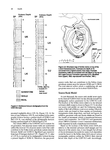
Figure 2.8. Structural map of Schlee dome on top of the
Lower Cretaceous (LK). Contours are depth (in ft)
UJ converted from original seismic time maps. Postsale
exploratory wells are annotated with the depth to the top of
L K 1 5 the Logan Canyon Formation equivalent (LK). (Modified
from Lippert, 1983; reproduced from Prather, 1991.)
source rocks that can contribute to the Schlee dome
1 6 petroleum system must lie between 19,500 and 31,500 ft.
TOTAL DEPTH The total interval within which a contributing oil- and
= 15,945 FT gas-prone source rock can lie is about 15,000 ft thick.
below
f· ' \:''1 SANDSTONE
sea level Source Rock Model
f�� SHALE As just discussed, the source rock model must apply
to the interval 15,000 ft thick that lies directly beneath the
� MARL stratigraphic section penetrated by the COST-B-2 well.
The location of the Schlee dome relative to the inferred
carbonate shelf margin is shown is Figure 2.5. To develop
Figure 2. 7. Baltimore Canyon stratigraphy from the
COST-B-2 well. our source rock model, we used the Cretaceous stratig
raphy of the Gulf of Mexico coast as an analog. Oil-prone
source rocks are found in three marine environments:
assumed negligible above 2.2% Ro (Figure 2.9). At the transgressive shale, slope shale, and back reef lagoon. In
time of trap formation, 0.9% Ro was attained at the strati addition, gas-prone coals and humic shales are found in
graphic horizon having a present depth of 22,500 ft and the fourth environment which is transitional between
that 2.2% Ro was attained at the stratigraphic horizon marine and nonmarine. The COST-B-2 well penetrated
having a present depth of 31,500 ft (Figure 2.10). about 7000 ft of Jurassic-Lower Cretaceous sedimentary
The bottom 3000 ft of the COST-B-2 well is mature for rocks deposited in such a transitional environment.
oil generation, but oil-prone source rocks are undetected Based on the location of the Schlee dome fetch area
within this interval. The oil-prone source rocks that could relative to the inferred carbonate shelf margin and the
contribute to the Schlee dome petroleum system must lie character of the seismic data, it was thought that all four
between 16,043 and 22,500 ft. Significant gas expulsion of the environments favorable for source rock deposition
from type III kerogen starts at 1.2% (Figure 2.9). A value would be found in the Schlee dome fetch area at various
of 1.2% Ro is reached at the stratigraphic horizon having stratigraphic positions within the 15,000-ft thick interval
a present depth of 19,500 ft. Therefore, the gas-prone below total depth of the COST-B-2 well. Accordingly,