
Page 40 - The Petroleum System From Source to Trap
P. 40
32 Smitl1
SEWARD PENINSULA
NORTON
SOUND
ST. LAWRENCE r/
SUBBASIN ") \
- '- ....
..... '�
\ "'''
\
\ '
COST 1�f
ARCO ,
CTS ARE DIFFERENT)
t
N
I
0 24
� OCS SALE 57 AREA
MILES
� PROSPECTS
#' L EADS
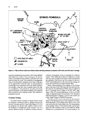
Figure 2.11. Map of Norton basin area offshore Alaska showing subbasins, prospects, COST wells, and OCS sale 57 acreage.
acquired a dominant lease position in the Stuart subbasin a thicker stratigraphic section is separated by a thinner
and drilled five wells on four structures. No hydro section. Three subbasins are shown on Figure 2.11 along
carbon accumulations that merited a drill-stem test were with the many prospects and leads within and between
found in these five wells. The availability of stratigraphic the subbasins. Also shown are the locations of the two
data and hydrocarbon indications from these wells gave COST wells drilled prior to the sale and the acreage put
us the opportunity to test the value of using petroleum up in OCS Sale 57 that was held in March 1983.
system logic as an exploration tool in the Stuart subbasin. Shell's understanding of the geology of the Norton
Accordingly, using only data available before the sale, basin at the time of the 1983 lease sale was derived from
we completed a "hypothetical" presale petroleum five sources: (1) publications of Fisher and co-workers of
system evaluation for the Stuart subbasin and compared the U.S. Geologic Survey (Fisher et al. 1979, 1981, 1982;
this evaluation to the drilling results. This material is Fisher, 1982), (2) Soviet publications, (3) the two COST
presented in part II. wells, (4) regional studies conducted by D. M. Worrall of
Shell Development Company, and (5) work carried out
Geologic Setting in the Alaska Division of Shell Oil Company.
Worrall's (1991) work was done on the tectonic
The Norton basin is located in Norton Sound under history of the Bering Sea and on the evolution of Tertiary
the offshore continental shelf of Alaska between the strike-slip basins of the Bering shelf. Much of his work
Seward Peninsula and the Yukon Delta (Figure 2.11). For was done before the Norton basin sale. His interpretation
our purpoes, the Norton basin outline is drawn where of the geologic history of the Norton basin was incorpo
the thickness of sedimentary rocks exceeds 1 sec on a rated into the evaluation made by the Shell Oil Alaska
seismic reflection profile. A subbasin is formed wherever Division and is presented here. To avoid confusion, we