
Page 255 - Well Logging and Formation Evaluation
P. 255
Solutions to Exercises 245
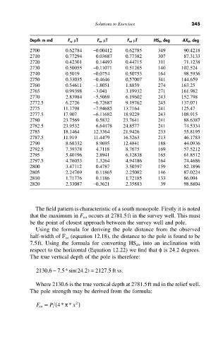
Depth m md F xy mT F ax mT F tot mT HS dir deg AX dir deg
2700 0.62784 -0.00412 0.62785 349 90.4218
2710 0.77294 0.03687 0.77382 307 87.3133
2720 0.42301 0.14493 0.44715 311 71.1238
2730 0.50055 -0.11071 0.51265 140 102.524
2740 0.5019 -0.0754 0.50753 164 98.5936
2750 0.33035 -0.4646 0.57007 341 144.659
2760 0.54611 -1.8051 1.8859 274 163.25
2765 0.99398 -3.041 3.19932 271 161.982
2770 2.83984 -5.5069 6.19602 243 152.798
2772.5 6.2726 -6.72687 9.19762 245 137.071
2775 11.1798 -7.94685 13.7164 241 125.47
2777.5 17.907 -6.11682 18.9229 243 108.915
2780 23.7569 0.5832 23.7641 241 88.6387
2782.5 23.9532 6.64478 24.8577 241 74.5334
2785 18.1464 12.3364 21.9426 233 55.8195
2787.5 11.919 11.4479 16.5263 213 46.1783
2790 8.68332 8.9695 12.4841 188 44.0936
2792.5 7.39378 4.7118 8.7675 169 57.5212
2795 5.40196 2.8941 6.12838 165 61.8512
2797.5 4.76053 1.3264 4.94186 164 74.4686
2800 3.47112 0.4787 3.50397 159 82.1896
2805 2.24769 0.11865 2.25082 146 87.0224
2810 1.71776 0.1186 1.72185 133 86.094
2820 2.33087 -0.3621 2.35883 39 98.8804
The field pattern is characteristic of a south monopole. Firstly it is noted
that the maximum in F tot occurs at 2781.5ft in the survey well. This must
be the point of closest approach between the survey well and pole.
Using the formula for deriving the pole distance from the observed
half-width of F tot (equation 12.18), the distance to the pole is found to be
7.5ft. Using the formula for converting HS dir into an inclination with
respect to the horizontal (Equation 12.22) we find that f is 24.2 degrees.
The true vertical depth of the pole is therefore:
-
.
.
.
2130 6 7 5*sin( 24 2) = 2127 5 ft ss.
.
Where 2130.6 is the true vertical depth at 2781.5ft md in the relief well.
The pole strength may be derived from the formula:
2
F tot = P (4** x )
p