
Page 97 - Acquisition and Processing of Marine Seismic Data
P. 97
88 2. MARINE SEISMIC DATA ACQUISITION
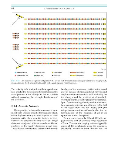
FIG. 2.44 An example navigation configuration of a spread with 10 streamers including several acoustic ranging units,
steering devices, depth levelers (birds), rGPS pods, speed logs and velocity sensors.
The velocity information from these speed sen- the shape of the streamers relative to the towed
sors attached to the outermost streamers enables array in the case of strong surficial currents and
us to perform a line change as fast as possible rough weather conditions as well as during the
without exceeding the strength limitations of line changes, and the positions of all available
the streamers. recording channels can be precisely determined.
Apart from mounting directly on the streamers,
these acoustic units are also attached to the hull
2.3.4 Acoustic Network
of the vessel, front and tail buoys, and gun
The separation between the streamers is mea- strings to communicate with each other for the
sured with specific acoustic transceivers which determination of the positions of all in-sea
utilize high-frequency acoustic signals to com- equipment within the spread.
municate with other acoustic devices in their They work between the 50 and 100 kHz fre-
vicinity and calculate the one-way slant range quency band with an acoustic range resolution
distances to adjacent units mounted on different of 5 mm. The acoustic ranging units are typically
positions on the nearby streamers in real-time. spaced at 100 m intervals along the streamers,
These devices enable us to observe and modify specifically located at front, middle and tail