
Page 297 - Facility Piping Systems Handbook for Industrial, Commercial, and Healthcare Facilities
P. 297
SITE UTILITY SYSTEMS
SITE UTILITY SYSTEMS 6.19
We will now discuss the first two items to be inserted into the rational formula needed
to size the stormwater disposal system: they are the area and imperviousness.
Area
The first figure in the rational formula is “A,” which is the area, in acres, of the tributary
area for any single drainage inlet or the entire site contributing area tip to the design point.
2
2
1 acre equals 43,560 ft (4070 m ).
Impervious Factor
The second figure is the determination of the impervious factor (I), sometimes referred to
as “C” (runoff coefficient). This dimensionless coefficient is that portion of the total rainfall
that is not lost to infiltration into the soil, ponding in surface depressions, water remaining
on vegetation or evaporation compared to the total rainfall that falls on an area and flows
over the ground to a drainage inlet. The coefficient depends on the slope of the land and the
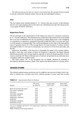
type of vegetation that is on it. The average figures for imperviousness of various surfaces
are found in Table 6.2. For ease of calculations, use a factor of 1.0 for roofs and roads, and
the like.
Inspection, if possible, is the best way to determine the nature of an existing surface.
In places where the exact nature of future development is uncertain, the figure selected
should represent the least loss that might be expected, to allow the largest quantify of storm
water to reach the DI. Where different types of surfaces are present on any particular area,
a weighed coefficient should be used.
The third criteria, “R,” is the maximum rate of rainfall, obtained by referring to
the intensity-duration-frequency charts. This requires the determination of a design storm,
DESIGN STORM
The rational method reduces an inexact set of conditions into an exact formula. Such vari-
ables as rainfall rate, overland water flow, and the amount of storm water that actually
TABLE 6.2 Imperviousness Factor for Surfaces
Flat slope, Average slope, Steep slope,
Surface less than 2% 2.0 to 7.0% 7.1% or more
Roofs & pavement (all types) * 0.95 0.95 0.95
Clay-sparse vegetation 0.40 0.55 0.70
Clay-lawn 0.15 0.20 0.30
Clay-dense vegetation 0.10 0.15 0.20
Clay-dense woods 0.07 0.12 0.17
Sand-sparse vegetation 0.20 0.30 0.40
Sand-lawn 0.07 0.12 0.17
Sand-dense vegetation 0.05 0.10 0.15
Sand-dense woods 0.03 0.08 0.13
*
For ease of calculation, the factor for roofs and pavement could become 1.0 if excessive runoff will not result in a
significant overdesign.
Source: Baltimore County Design Standards.
Downloaded from Digital Engineering Library @ McGraw-Hill (www.accessengineeringlibrary.com)
Copyright © 2009 The McGraw-Hill Companies. All rights reserved.
Any use is subject to the Terms of Use as given at the website.