
Page 127 - Geochemical Anomaly and Mineral Prospectivity Mapping in GIS
P. 127
126 Chapter 5
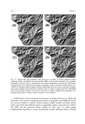
Fig. 5-5. Spatial data and sequential steps involved in creation of stream sediment sample
catchment basins. (A) Digital elevation model (DEM) created either manually from analogue
topographic elevation data or automatically from digital topographic elevation data. (B) Stream
networks (black lines) digitised from analogue topographic maps or delineated automatically from
a DEM. (C) Stream sediment sample locations (small white dots) are used as references in further
processing of digital stream networks to indicate points to which overland water flows. (D) DEM
and processed digital streams are used as input data in spatial neighbourhood algorithms for
automatic delineation of sample catchment basins (in white outlines).
A DEM can be used for automatic determination of stream networks (e.g., Martz and
Garbrecht, 1993) instead of digitising streams from a topographic map. Digitised streams
are processed further to indicate stream sediment sample locations as points toward
which water flows from different points on topographic surfaces represented by a DEM.
The DEM and the processed digital streams are then used via certain spatial
neighbourhood algorithms to create automatically sample catchment basins. Detailed