
Page 170 - Hydrocarbon Exploration and Production Second Edition
P. 170
Reservoir Description 157
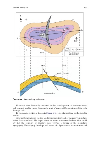
Figure 6.43 Structural map and section.
The maps most frequently consulted in field development are structural maps
and reservoir quality maps. Commonly a set of maps will be constructed for each
drainage unit.
To construct a section as shown in Figure 6.43, a set of maps (one per horizon) is
needed.
Structural maps display the top (and sometimes the base) of the reservoir surface
below the datum level. The depth values are always true vertical subsea. One could
say that the contours of structure maps provide a picture of the subsurface
topography. They display the shape and extent of a hydrocarbon accumulation and