
Page 238 - Earth's Climate Past and Future
P. 238
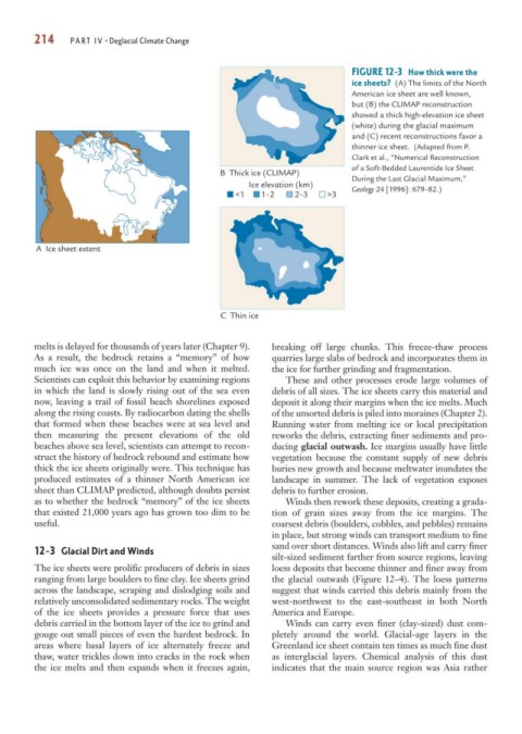
214     PART IV • Deglacial Climate Change


                                                                             FIGURE 12-3 How thick were the
                                                                             ice sheets? (A) The limits of the North
                                                                             American ice sheet are well known,
                                                                             but (B) the CLIMAP reconstruction
                                                                             showed a thick high-elevation ice sheet
                                                                             (white) during the glacial maximum
                                                                             and (C) recent reconstructions favor a
                                                                             thinner ice sheet. (Adapted from P.
                                                                             Clark et al., “Numerical Reconstruction
                                                                             of a Soft-Bedded Laurentide Ice Sheet
                                                 B  Thick ice (CLIMAP)
                                                                             During the Last Glacial Maximum,”
                                                                             Geology 24 [1996]: 679–82.)
                                                       Ice elevation (km)
                                                    <1    1–2    2–3    >3


         A  Ice sheet extent


                                                 C  Thin ice

        melts is delayed for thousands of years later (Chapter 9).  breaking off large chunks. This freeze-thaw process
        As a result, the bedrock retains a “memory” of how  quarries large slabs of bedrock and incorporates them in
        much ice was once on the land and when it melted.   the ice for further grinding and fragmentation.
        Scientists can exploit this behavior by examining regions  These and other processes erode large volumes of
        in which the land is slowly rising out of the sea even  debris of all sizes. The ice sheets carry this material and
        now, leaving a trail of fossil beach shorelines exposed  deposit it along their margins when the ice melts. Much
        along the rising coasts. By radiocarbon dating the shells  of the unsorted debris is piled into moraines (Chapter 2).
        that formed when these beaches were at sea level and  Running water from melting ice or local precipitation
        then measuring the present elevations of the old    reworks the debris, extracting finer sediments and pro-
        beaches above sea level, scientists can attempt to recon-  ducing glacial outwash. Ice margins usually have little
        struct the history of bedrock rebound and estimate how  vegetation because the constant supply of new debris
        thick the ice sheets originally were. This technique has  buries new growth and because meltwater inundates the
        produced estimates of a thinner North American ice  landscape in summer. The lack of vegetation exposes
        sheet than CLIMAP predicted, although doubts persist  debris to further erosion.
        as to whether the bedrock “memory” of the ice sheets   Winds then rework these deposits, creating a grada-
        that existed 21,000 years ago has grown too dim to be  tion of grain sizes away from the ice margins. The
        useful.                                             coarsest debris (boulders, cobbles, and pebbles) remains
                                                            in place, but strong winds can transport medium to fine
                                                            sand over short distances. Winds also lift and carry finer
        12-3 Glacial Dirt and Winds
                                                            silt-sized sediment farther from source regions, leaving
        The ice sheets were prolific producers of debris in sizes  loess deposits that become thinner and finer away from
        ranging from large boulders to fine clay. Ice sheets grind  the glacial outwash (Figure 12–4). The loess patterns
        across the landscape, scraping and dislodging soils and  suggest that winds carried this debris mainly from the
        relatively unconsolidated sedimentary rocks. The weight  west-northwest to the east-southeast in both North
        of the ice sheets provides a pressure force that uses  America and Europe.
        debris carried in the bottom layer of the ice to grind and  Winds can carry even finer (clay-sized) dust com-
        gouge out small pieces of even the hardest bedrock. In  pletely around the world. Glacial-age layers in the
        areas where basal layers of ice alternately freeze and  Greenland ice sheet contain ten times as much fine dust
        thaw, water trickles down into cracks in the rock when  as interglacial layers. Chemical analysis of this dust
        the ice melts and then expands when it freezes again,  indicates that the main source region was Asia rather