
Page 105 - Geochemical Anomaly and Mineral Prospectivity Mapping in GIS
P. 105
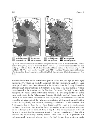
104                                                             Chapter 4


             Fig. 4-14. Spatial distributions of different background levels of Co in stream sediments, Aroroy
             district (Philippines), based on thresholds defined from the (A) continuous surface of the Co data
             and (Fig. 4-12D and Table 4-I) (B) discrete catchment basin surface of the Co data (Fig. 4-13D
             and Table 4-I). VL = very low; L = low; H = high; VH = very high. Triangles represent locations
             of epithermal Au deposit occurrences, whilst thin black lines represent lithologic contacts (see Fig.
             3-9).


             Mandaon Formation. In the southwestern  portion  of the area, the high  (to very  high)
             background Co  values are spatially associated with the  Nabongsoran  Andesite, large
             outcrops of which have been observed  to  be intrusive  into the Lanang Formation
             although much smaller outcrops (not mappable at the scale of the map in Fig. 3-9) have
             been  observed to be intrusive into the Mandaon Formation. The  high  (to very high)
             background Co values in the southwestern portion of the area are plausibly due to the
             more  mafic facies in the  Nabongsoran  Andesite. Similarly, the high background Co
             values in the northwestern portion of the area are plausibly due to the more mafic facies
             in smaller intrusive units of the Nabongsoran Andesite, which are not mappable at the
             scale of the map in Fig. 3-9. However, the strong correlation of Co with Mn (see Table
             3-V) suggests that the high (to very high) background Co values in the southwestern
             portion of the area are also plausibly due to scavenging by co-precipitation with Mn-
             oxides in the surficial environment. Note in Fig. 4-11 that the southwestern portion of
             the area is characterised by topographic lows (i.e., low-energy environment), into which
             westerly and  southwesterly  flowing streams  carry their load. It is plausible that
             hydromorphically dispersed  elements (e.g., Co, Mn) derived  from weathered rocks