
Page 80 - Integrated Wireless Propagation Models
P. 80
58 C h a p t e r T w o
A
a:>
.lE
. !: 1 0 00
c
0 / / "
� 800 v-.." / v-
>
Q)
[iJ 600 �./ I � /
"
v( I \ " v
400
/I � - f--- - f---- - - � � v
-
200
0
B �
a:l
"0
. !: 1 2 0 10 "--
en � �-....._
en
_Q � "' "- -......
c 30 MHz
0 � -......
"Ui 1 4 0 1\ � :...'- 1- I
en
. E \ -::::::: r----- ,- -......
en I" I ' r----- ==J-......_ �
c Smooth earth �
Cll "-� -...... � �
t= 1 6 0 J =-= Above profile ! -......
-......,
300� � -....._
�
1 8 0 I I -..........___
0 1 0 20 30 40 50 60
Miles
d
M
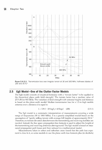
FIGURE 2.4.2.1 Transmission loss over irregular terrain at 30 and 300 H z; half-wave i p oles of
250 and 30 ft. 5
2.5 Egli Model-One of the Clutter Factor Models
The Egli model consists of empirical formulas with a "terrain factor" to be applied to
the theoretical plane earth field strength.6 The terrain factor has a median value of
27.5 dB for 900 MHz. The variation of field strength with antenna heights and distance
1
is based on the plane earth model. Median transmission loss for a . 5-m-high mobile
antenna over a distance d is equal to
L = 139. - 2 0 loghb +40 logd (dB) (2.5.1)
1
The Egli model is a systematic interpretation of measurements covering a wide
range of frequencies (90 to 1000 MHz). It is a greatly simplified model based on the
assumption of "gently rolling terrain with average hill heights of approximately 50 ft."
Therefore, no terrain elevation data between the transmitting and receiving facilities are
needed. Instead, the free space propagation loss formula is used to adjust the height of
the transmitting and receiving antennas aboveground. The Egli model is based on mea
sured propagation path losses and then reduced to a mathematical model.
Measurements taken in urban and suburban areas found that the path loss expo
nent is close to 4, so some models to use the plane earth loss formula plus (in decibels)