
Page 206 - The Geological Interpretation of Well Logs
P. 206
- THE GEOLOGICAL INTERPRETATION OF WELL LOGS -
NNE
SSW
B. Dip ——» DIP AZIMUTH (degrees)
(¥)
g° 10° 20° 30° 60° o 180 360 :
om a : mean
3 azimuth
~ 2
r 8 e FAULT ZONE
=
8 & stdke
93°
2
q FAULT ZONE sy ~ >
fl
pip NoRTH_||_ S
=
a 2
lt ; s Ss
5Qm P , } : 2 ® - 2 azimuth
mean
3
C. Dip —» DIP AZIMUTH (degrees) G)
0° 40° 20° 30° 60° 0 480 360
40m z
a : £
a & FAULT
=
. * FAULT % <£ stvike 93”
2 a L _ 2 ¢
. DIP "2.
NORTH Z $
fer Q
si o
: : - o
50m 3
*
3
3
:
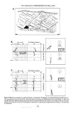
Figure 12.38 Outcrop example of a small normal fault, A, cliff profile. The diplogs were measured through the fault across a
wave-cut platform in front of the cliff. B. 130m from the cliff, showing a well-defined fault and azimuth change. C. 230m from
the cliff showing no dipmeter changes across the fault. The example illustrates that character may change along the same fault
and that a fault may not be detected by the dipmeter when there is no geometrical change (measurements by C. Townsend and
R. Sutherland). 196