Page 30 - The Geological Interpretation of Well Logs
P. 30

-  THE  GEOLOGICAL  [INTERPRETATION  OF  WELL  LOGS  -


                                                           COUNTRY-NGRIH       SEA    LAT-S70  SIM  N.
      //3-                                                 COMPANY -AMNOCO           LONG-020  45M  E.
                  |

                    TEMPERATURE             CONDUCTIVITY        HEAT   FLOW       LT THOLOGY      AGE
                         HOEG-C.1               UW.  70  DEG.)     (AW.  AN)
                .   200   6  400—CG   M20   4d   OO   4   2   3   4   §&   6   90   60   70  80   90  140


             $00   ‘
                   .                                             ;               clay           u  TERTIARY
            1000


            1800
                         “27.6  GEG.C.  san.

                                                                                 SHALE          PALE  OCE NE

            2000
         DEPTH   IMETRES)
                                                                                 CHALK
                                                                                                ue  CRET.
                                                                                 SHALE  /HARC
                                                                                                L.  CRET.
            2500
                                                                                                    TC
                                                                                                LURASS
            3000
            3800

                                                                                                YU.  PERBIRN
                                                                                 HAL  J  TE  ZANHTOR  STE
            4000
                                                                  aL
                                                                                   SHALE  SALTS  .745S1.
                                                                                                 L.  PERMIAN
            4500
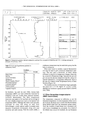
        Figure  3.1  Temperature  gradient,  thermal  conductivity  and  heat  flow  compared  in  North  Sea  well  7/3-1.  Lithology  and  age  are
        indicated.  (From  Evans,  1977).

        Table  3.2  Some  typical  geothermal  gradients  in   continuous  temperature  may  be  read  either  going  into  the
        sedimentary  basins.                               hole  or  coming  out.
                                                             When  more  detail  is  needed,  a  special  thermometer
                                 Gradient
                                                           tool  may  be  used  to  give  continuous  temperature  read-
                                 °CéAm        °F/1OOft
                                                           ings.  The  tool  uses  a  thermistor,  or  metal  whose

         Rhine  Valley           66           3.6          resistance  is  sensitive  to  temperature  changes,  fitted  into
         Red  Sea                45           2.5          the  circuit  of  a  Wheatstone  bridge.  Typically  the  tool  will
         Central  Ruhr  basin    40           2.2          give  not  just  the  absolute  temperature  but  also,  using  two
         Madagascar              38           2.1          separate  thermistors,  a  temperature  differential.  Such  is
         Western  Canada,  Alberta*   31.8    1.8
                                                           the  case,  for  instance,  in  the  Temperature  Survey  of Atlas
         Mississippi  (typical)*   29         1.6
                                                           Wireline  (Figure  3.4).
         Louisiana  (typical}*   24           1.3
                                                             The  absolute  accuracy  of  temperature  logs  is  generally
         Eastern  Canada*        22           1.2
                                                           not  good  and  is  in  the  region  of  +2.5°C  (15°F),

         *typical  oil  regions                            although  the  resolution  is  good,  around  0.025°C  (0.05°F)
                                                           (Hill,  1990),
        the  borehole.  Up  until  the  mid  1980s,  bottom  hole
        temperature  (BHT)  was  most  commonly  measured  by
                                                           3.3  True  formation  temperatures
        strapping  to  the  tool,  usually  three,  pressure  resistant,
                                                           (BHT  corrections)
        maximum  thermometers.  The  three  temperatures
        (maxima)  were  noted  on  the  log-head,  and  an  average  or   The  temperature  measured  in  boteholes  is  not  the
        the  most  reliable  temperature  used  as  the  bottom  hole   formation  temperature,  it  is  the  temperature  of  the  mud  in
        temperature  (BHT).  Although  this  habit  is  still  generally   the  borehole.  Borehole  mud  is  cooler  than  the  formations
        continued,   in   every  tool   string  (at  least  from   being  drilled  (apart  from  the  immediate  surface  strata).
        Schlumberger),  a  small,  special  sonde  is  included  which   Thus,  the  invasion  of  mud  filtrate  into  a  formation  will
        measures  temperature  continuously  along  with  mud   cool  it  down  immediately  by  convection.  As  a  result  of
        resistivity  and  cable  tension.  With  this  sonde  (AMS),  a   the  infinite  mass  around  the  borehole,  the  true  formation

                                                       20
   25   26   27   28   29   30   31   32   33   34   35