
Page 29 - The Geological Interpretation of Well Logs
P. 29
3
TEMPERATURE
LOGGING
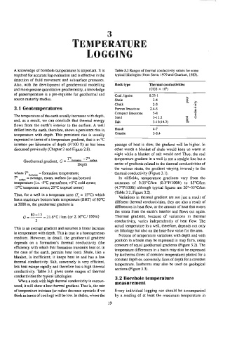
A knowledge of borehole temperatures is important. It is Table 3.1 Ranges of thermal conductivity values for some
required for accurate log evaluation and is effective in the typical lithologies (from Serra, 1979 and Gearhart, 1983).
detection of fluid movement and subsurface pressures.
Also, with the development of geochemical modelling Rock type Thermal conductivities
and more precise quantitative geochemistry, a knowledge (CGS X 10)
of geotemperature is a pre-requisite for geothermal and
Coal, lignite 0.33-1 L
source maturity studies. Shale 2-4 8
Chalk 2-3 £
3.1 Geotemperatures Porous limestone 2.4-5 RB
Compact Limestone 5-8 3
The temperature of the earth usually increases with depth,
Sand 3-12.2 3 3
and, as a result, we can conclude that thermal energy Salt 3-15(14.3) 50
flows from the earth’s interior to the surface. A well
drilled into the earth, therefore, shows a persistent rise in Basalt 4-7
Granite 5-8.4
temperature with depth. This persistent rise is usually
expressed in terms of a temperature gradient, that is in °C
increase per kilometre of depth (F/100 ft) as has been passage of heat is slow, the gradient will be higher. In
discussed previously (Chapter 2 and Figure 2.8). other words a blanket of shale would keep us warm at
night while a blanket of salt would not! Thus, the real
temperature gradient in a well is not a straight line but a
7”
Geothermal gradient, G = P comsion
sutace
Depth series of gradients related to the thermal conductivities of
the various strata, the gradient varying inversely to the
where T° .. saion = formation temperature; ~ thermal conductivity (Figure 3.1).
T” vntce = Average, Mean, surface (or sea bottom) In oilfields, temperature gradients vary from the
temperature (i.e. -5°C permafrost; +5°C cald zones; extremes of 0.05°C/km (0.3°F/100ft) to 85°C/km
15°C temperate zones; 25°C tropical zones) (4.7°F/100ft) although typical figures are 20°-35°C/km
(Table 3.2, Figure 3.2).
Thus, for a well in a temperate zone (7, = 15°C) which
Variations in thermal gradient are not just a result of
has a maximum bottom hole temperature (BHT) of 80°C
different thermal conductivities, they are also a result of
at 3000 m, the geothermal gradient is
differences in heat flow, or the amount of heat that enters
the strata from the earth’s interior and flows out again.
80-15
(or 2.16°C/ 100m)
G= =21.6°C/km Thermal gradient, because of variations in thermal
conductivity, varies independently of heat flow. The
actual temperature in a well, therefore, depends not only
This is an average gradient and assumes a linear increase
on lithology but also on the heat-flow value for the area.
in temperature with depth. This is true in a homogeneous
Notions of temperature variations with depth and with
medium. However, in detail, the geothermal gradient
position in a basin may be expressed in map form, using
depends on a formation’s thermal conductivity (the
contours of equal geothermal gradients (Figure 3.2). The
efficiency with which that formation transmits heat or, in
temperature differences in a basin may also be expressed
the case of the earth, permits heat loss). Shale, like a
by isotherms (lines of constant temperature) plotted for a
blanket, is inefficient; it keeps heat in and has a low
constant depth or, conversely, lines of depth for a constant
thermal conductivity. Salt, conversely is very efficient,
temperature. Isotherms may also be used on geological
lets heat escape rapidly and therefore has a high thermal
sections (Figure 3.3).
conductivity. Table 3.1 gives some ranges of thermal
conductivities for typical lithologies.
3.2 Borehole temperature
When a rock with high thermal conductivity is encoun-
measurement
tered, it will show a Jow thermal gradient. That is, the rate
of temperature increase (or rather decrease upwards if we Every individual logging run should be accompanied
think in terms of cooling) will be low. In shales, where the by a reading of at least the maximum temperature in
19